English
* Search Name or Package Name
* Search Name or Package Name
Category:Productivity
Version:1.21.5
Size:46.72M
Updated:2024-03-28
Language:English
Ratings:162
Package ID:menion.android.locus.gis
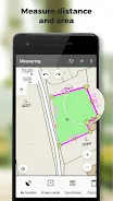
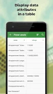
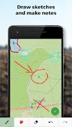
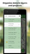
Locus GIS offline land survey is a professional and versatile app specifically designed for offline fieldwork with geodata. Whether you're an environmentalist, forester, farmer, energy distributor, urban planner, or construction worker, this app is your ultimate tool for collecting, viewing, and updating data in the field. With this app, you can easily save points with precise or arbitrary positions, create lines and polygons by recording motion, and customize attributes. You can even attach photos, videos, audio files, or drawings to your data for comprehensive documentation. The app supports a wide range of maps, both online and offline, and offers advanced tools for measuring distances and areas. It also allows you to search and filter data, edit styles and text labels, and organize your data into layers and projects. Whether you're conducting ecological surveys, managing forests, planning wind farms, or constructing roads, this app is the perfect offline companion for all your land survey needs.
* Offline data collection: The App allows users to collect and update field data even without an internet connection.
* Versatile data storage: Users can save points with current or arbitrary positions, create lines and polygons by motion recording, and set attributes for easy organization.
* Multimedia attachments: Users can attach photos, videos/audio, or drawings to their data, providing valuable visual documentation.
* Guided navigation: The App offers guidance to points, making it easier for users to locate specific targets during fieldwork.
* Import/Export capabilities: The App supports importing and editing ESRI SHP files, as well as exporting data to ESRI SHP or CSV files, allowing seamless integration with other GIS software.
* Map support: The App offers a wide range of online and offline maps, including support for WMS sources, MBTiles, SQLite, MapsForge, TAR, GEMF, and custom OpenStreetMap data or map themes.
Locus GIS offline land survey is a professional GIS application designed for offline fieldwork, making it the ideal tool for a variety of industries, including environmental data collection, forestry management, agriculture, energy distribution, wind farm planning, mining exploration, urban facility surveying, and road construction. With its extensive features that enable efficient data collection, storage, navigation, and integration, this app is a must-have for professionals in these industries. Download now to streamline your fieldwork and optimize your data management processes.


chinese dating site in usa
Download

LoveToo.Me
Download

Milan - Dating App
Download

Japanese dating and friends - Language exchange
Download

Men Radar - Free dating with single boys and men.
Download

BBW SSBBW DATING CHAT APP
Download

Gay Chat: Gay Chat Room
Download

Rendez-vous : La vraie rencontre
Download

Lovappy: Voice Chat, Game Show
Download

Local dating app nearby me
Download

ZR Play
Download

Hair Fall Control Tips
Download

Super High Volume Booster - Loud Sound Booster
Download

Wisenet mobile
Download

XRecorder
Download
BBW SSBBW DATING CHAT APP
Download

CardioVisual: Health Education
Download

Tagged Plus
Download

Mint Messenger - Chat & Video
Download

Skymet Weather
Download

Copyright © 2025 51wma ALL Rights Reserved
yoooohary@gmail.com